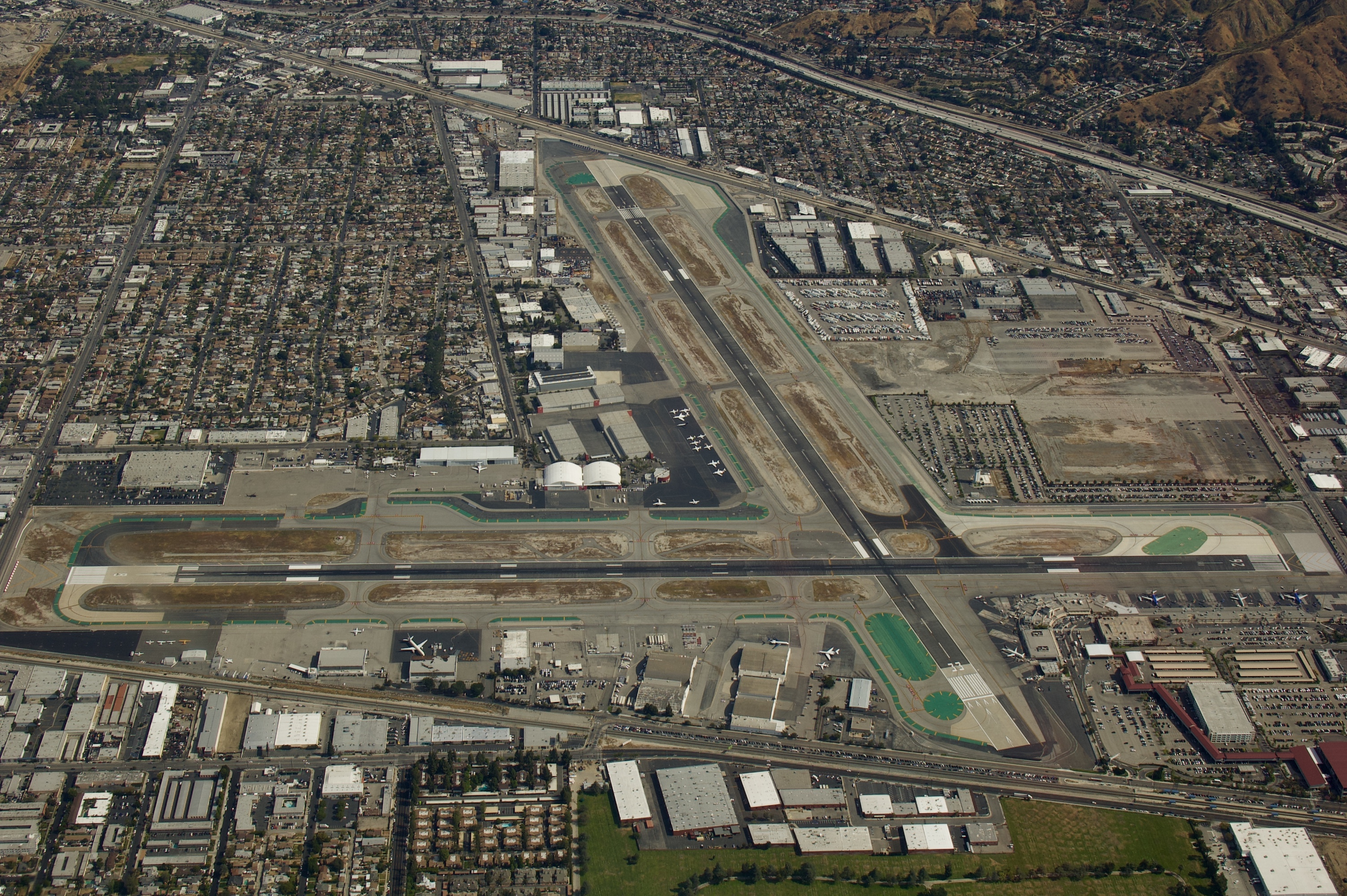
¶ Bob Hope Airport Standard Operating Procedures

Welcome to the Bob Hope Airport SOP.
This manual provides guidelines for the control of air traffic at the Burbank Tower. All air traffic personnel are required to be familiar with its contents. These procedures supplement the Air Traffic Control Handbook, Order 7110.65, and the Facility Operation and Administration Handbook, Order 7210.3. If you encounter a situation not covered in this manual, utilize your best judgment and bring the situation to the attention of the ARTCC manager(s).
- ICAO: KBUR
- Airspace: Class C
- TRACON: Southern California TRACON (KBUR)
- Field Elevation 778 ft
The following links provide information relating to the Bob Hope Airport. This includes, but is not limited to:
- Airport Diagram, SIDs, STARs, IAPs
- Information from the Airport/Facility Directory
- Sectional and Terminal Aerodrome Charts, Low- and High Altitude Enroute IFR charts
- Routing of aircraft as can be derived from real world flights
Links:
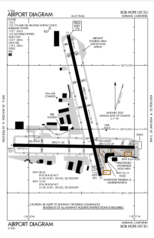
- Bob Hope Airport Diagram
- AirNav - Bob Hope Airport
- SkyVector - Bob Hope Airport
- Bob Hope Airport TAC Chart
- IFR Flight Route Analyzer
¶ Shortcuts - KBUR
Clearance delivery will be handled by GND
Ensure all filed flight plans comply with the procedures in this document.
¶ Procedures
Aircraft departing Bob Hope airport IFR shall be assigned a SID and Transition.
RV = Radar Vectors
| SID name | Pronounciation | Transition | Aircraft type | Runways |
|---|---|---|---|---|
| ELMOO# | ELMOO | SLI LAX | ALL | ALL |
| OROSZ# RNAV RV | OROSEZ | CSTRO COREZ | ALL | ALL |
| SLAPP# RNAV RV | SLAP | HAILO LAS MISEN HEC BLH | TURBOJET | ALL |
| VNY# RV | VAN NUYS | FIM GMN AVE PMD DAG | ALL | ALL |
| VVERA# RNAV RV | VERA | HEC DAG | TURBOPROP | ALL |
¶ IFR Altitude Assignment
Ensure aircraft will climb via SID on departures that have a top altitude. In case of a missing top altitude on the given SID, aircraft shall climb and maintain 10,000ft on departure.
¶ Required Routes SCT -> L30
Southern California TRACON and Las Vegas (L30) TRACON have a Letter of Agreement detailing required routes between SOCAL and L30:
Maximum altitude FL290, lower is acceptable. Higher available only on pilot request Enroute.
¶ Required Routes SCT -> NCT
Southern California TRACON and Northern California (NCT) TRACON have a Letter of Agreement detailing required routes between SOCAL and NCT.
¶ Tower Enroute Control (TEC) Routes
The FAA has created a set of routes used for aircraft flying between most Southern California Airports. These are called Tower Enroute Control (TEC) Routes. If a TEC route is available between two airports, aircraft are required to be routed via that TEC route for the given airport configuration, altitude, and aircraft type.
Appropriate TEC routes should always be filed unless in conflict with this document. Only clear the pilot using the name of the TEC route if a TEC route (not necessarily the same one) was filed/requested, otherwise expand the TEC route and issue it as a full-route clearance.
An example clearance for a J-CLASS aircraft using the named TEC route “LAXP11” (KLAX->KSAN ) would be:
Cleared to the San Diego airport, via the LOS ANGELES PAPA ONE ONE routing, maintain 5,000, expect 13,000 ft 5 minutes after departure …
The pilot would then fly the route: LAXX1 MZB
TEC routes are available at FAA NFDC Preferred Routes Database
¶ GND
Control positions
| Position | Frequency | FRA |
|---|---|---|
| KBUR_GND | 123.900 MHz |  |

¶ Restrictions
Heavy aircraft such as the Boeing 747 and Airbus A380 are not permitted to land at this airport.
¶ Taxi Instructions
- The ground controller must make sure that an aircraft has received an IFR clearance and has reported receipt of current weather information before taxi instructions may be issued.
- Aircraft must operate their transponder in altitude reporting mode (mode S/C) whenever the transponder is enabled. This includes all movement areas, all non-movement areas, and all airspace at or below FL600 within thirty (30) nautical miles of the LAX VOR (the “Mode C Veil”, marked on the Los Angeles Sectional and Los Angeles Terminal Area Chart).
¶ Closed Traffic
If closed traffic/pattern work is requested, coordinate with the Tower controller (if online) before issuing taxi instructions. If no tower/approach controller is online, then after taxi and before takeoff issue the following:
Tower control services unavailable. Report pattern legs on advisory frequency 122.8. Takeoff at own risk. Good day.
Control positions
| Position | Frequency | FRA |
|---|---|---|
| KBUR_TWR | 118.700 MHz |  |
Airport
¶ Runway configuration
- East (Default Configuration): Departures 15, Arrivals 08
| Designator | Dimensions |
|---|---|
| 15/33 | 6886 x 150 |
| 08/26 | 5802 x 150 |
Should the headwind for runway 08 increase above 15 knots, the configuration shall be changed to handling both departures and arrivals on runway 08.
- West (Winds >10kt to the east): Departures 26, Arrivals 33
| Designator | Dimensions |
|---|---|
| 15/33 | 6886 x 150 |
| 08/26 | 5802 x 150 |
Should the headwind for runway 26 increase above 15 knots, the configuration shall be changed to handling both departures and arrivals on runway 26.
¶ Go-around Procedures
| Runway | Procedure |
|---|---|
| 08 | Climb to 6,000ft on heading 110 |
| 15 | Climb to 6,000ft on heading 200 |
| 26 | Climb to 6,000ft on runway heading |
| 33 | Climb to 8,000ft on heading 290 |
¶ VFR Closed Traffic Operations
Pattern Directions
| Runway | Direction |
|---|---|
| 08 | RIGHT |
| 15 | N/A |
| 26 | LEFT |
| 33 | N/A |
Pattern not allowed on runway where direction is marked N/A.
¶ Southern California TRACON (Burbank)
Control position
| Position | Frequency | FRA |
|---|---|---|
| KBUR_APP | 134.200 MHz |  |
Southern California TRACON (Burbank) is a TRACON responsible for the airspace from the surface to the buffer zone between 13,000 feet and 15,000 feet shared by SoCal TRACON and LA Center. This buffer zone allows SCT to clear aircraft up to 15,000ft and hand them off to LA Center at 13,000ft. It also allows LA Center to clear aircraft down to 13,000ft and hand them off to SCT at 15,000ft.
KBUR_APP is referred to on frequency as “SoCal” or professionally as the “Southern California TRACON” and the position as a whole should not be referred to by controllers as “SoCal Approach” as this would (incorrectly) imply the existence of a KBUR_DEP position.
“SoCal Approach” or “SoCal Departure” may be used by pilots to refer to a SoCal controller while radar approach or departure services (as appropriate) are being provided, but these labels are not intrinsic to the position and (for example) the same controller may be referred to by three different pilots on the same frequency as “SoCal”, “SoCal Approach”, and “SoCal Departure” depending on the services being received and the personal preferences of the pilots.
Pilots should endeavor to use “SoCal” as the radiotelephony callsign for the station whenever possible.
Typical departure clearance after takeoff:
Radar Contact, Climb and maintain One-Five Thousand Feet
KBUR_APP will then hand off traffic no later than 13,000 feet to Los Angeles Center (KZLA) or UNICOM.
¶ Procedures
Bob Hope Airport
¶ Standard Terminal Arrival (STAR) Procedures
| STAR name | Pronounciation | Transition | Approach |
|---|---|---|---|
| FERN# | FERNANDO | FIM OHIGH DERBB AVE FLW | |
| JANNY# RNAV | JANNY | WNCHL KREME PURSE WELUM EED BUGGA | RNV08-Y |
| LYNXX# | LYNX | LHS PMD DAG HEC | |
| ROKKR# RNAV | ROCKER | PRPLE HIHWY HONZK RDHOT REBRG | |
| THRNE# RNAV | THORNE | PHRED | |
| WEESL# RNAV | WEASEL | NINTY EHF WRING |
¶ Instrument Approach Procedures (IAP)
All IAPs can be found here.
¶ Changes
| Date | Changes | VID |
|---|---|---|
| Jan 2024 | Original SOP | 658565 |